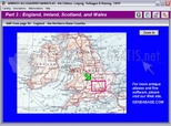
Atlas of Britain and Ireland 1899
- Categoría: Geography
- Licencia: Freeware
- Tamaño: 31.55 KB
- Sistema: w98 wNT wME w2000 wXP
- Idiomas:

An impressive Atlas of Britain and Ireland from 1899 with colour maps.
The whole of England, Scotland, Ireland and Wales is contained in this magnificent Atlas from 1899. Without doubt Atlas of Britain and Ireland 1899 is the most important cartographic and geographic document of the 19th Century.
Atlas of Britain and Ireland is a document you must consult to understand the sharing and establishment of countries and continents before 1974, when everything was restructured.
Atlas of Britain and Ireland 1899 is scanned with a resolution of 300dpi, with more than 75 colour maps. In summary, it is an essential work for geographers, historians and geneologists.
DownloadAtlas of Britain and Ireland 1899 related downloads
Theenk World Capitals 1.0.0.31
 Download
A geographic tool to learn the world's main capital cities and the US states.